• Allows pilot to easily visualize possible tasks and goals
• Automatic evaluation of tasks for FAI badge compliance, with diagnostics
• Eliminates the need to mark up Sectionals by hand
• Based on FAA sourced and scanned Sectionals
• Produces automatic contoured lines of glide elevation for intuitive planning
• Easily explore impact of arrival altitude and glider performance on goals or tasks
• Great for instructors, and students learning cross country techniques
• Transparency and fully customized colors and line widths increase map legibility
• Outputs printed maps at Sectional scale, with automatic map legend
• Quickly update saved maps with new landouts, or eliminate dated ones
• Runs on Mac OSX, or Windows 2000/NT/XP
• Free Sectional maps of the U.S. available on this site
Glideplan Software Features
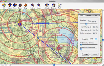
GlidePlan gives you complete control of the flight parameters that create the contour rings. Set the glide ratio and arrival altitude you feel comfortable with given your skill level. As you gain experience, you can tweak the parameters to your liking and print new maps. Perhaps you want an emergency map in the cockpit that shows aggressive glide and arrival altitudes and includes every usable landout. Perhaps you are flying in a new area or with a rental and want a map that reflects conservative thinking.
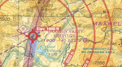
GlidePlan maps are very high resolution so every detail of the original can be seen. You have complete control over the appearance of the graphic overlays, including color, transparency, and line thickness. Printed maps match the scale of the original Sectionals. You can print a selected area, tile the whole map on to multiple pages, or get the full size map printed professionally by us, and mailed to you.
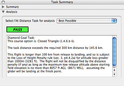
It's easy to create tasks by clicking on the map and laying down turnpoints. In addition to heading, distance and duration, GlidePlan has built in analysis software that evaluates the task's suitability for FAI distance badges. List every badge the task qualifies for, or select a specific badge to learn what type of distance penalties the flight may be subject to. Find out what the max release altitude is to avoid disqualification. Move, add or delete turnpoints to find the right course for the conditions of the day, or the goal you are trying to reach.